Weymouth Back River ACEC Designation Document
Approximate Acreage: 950 acres
Watershed(s): Boston Harbor (Weymouth/Weir)
Municipalities: Hingham and Weymouth
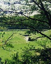
The Weymouth Back River ACEC comprises approximately 950 acres in Hingham and Weymouth. It is an unusual natural area
in the midst of an urban/suburban environment, uniquely preserved considering
its proximity to Boston. Approximately 180 acres are tidal waters flushing into Hingham Bay. There are productive clam flats and nursery and feeding areas for a wide variety of finfish. Herring Brook in Weymouth provides annual passage to Whitmans Pond for thousands of alewives, locally referred to as herring. The lower portion of Herring Brook, Hingham's Fresh River, and several unnamed tributaries provide spawning sites for an annual smelt run. The 100+ acres of salt marsh and several salt ponds are vital links to the marine food web. Also included in the ACEC are ponds and swamps that form the headwaters of various tributaries to the Weymouth Back River.
Most of the uplands within the ACEC are parks managed by the two towns: Great Esker Park in Weymouth and Hingham's Bare Cove and Brewer-More Parks. Within these areas are several outstanding examples of glacial eskers - the size and scope of the eskers are unique in Massachusetts. There are also numerous historical sites, including evidence of prehistoric habitation as long ago as 500 to 7500 B.C. Breeding or feeding habitat for some 150 species of birds combines with the scenic quality of the parks. These conservation areas provide buffers for the waters of the river and space for passive recreation.
Water Bodies included (partially or entirely) in the ACEC
- Harbors, Sounds, Bays: none
- Rivers: Fresh River (Hingham); Weymouth Back River (Hingham, Weymouth)
- Lakes, Ponds: Bouve Pond (Hingham); Brewer Pond (Hingham); Whitmans Pond (Weymouth)
- Wetlands: Bear Swamp (Hingham)
- Brooks, Creeks: Herring Brook (Weymouth)
- Barrier Beaches included in ACEC: none
Maps
Weymouth Back River ACEC - Index
Weymouth Back River ACEC Map 28a
Maps are intended to be used with the written boundary description contained in the ACEC designation document. The mapped boundary is not to be used by itself for definitive ACEC boundary delineation or regulatory interpretation. For review of site-specific projects in or bordering the ACEC, determinations must be made in the field by a certified professional in consultation with the appropriate Conservation Commission(s) and ACEC Program Staff.