
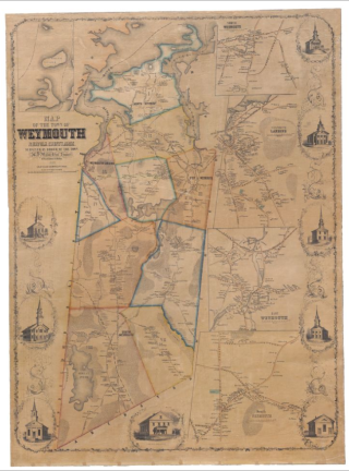
Map of the Town of Weymouth, Norfolk County, Mass. (1853)
A high-resolution digital image of this map is available on Digital Commonwealth.
Henry Francis Walling
American, 1825-1888
Map of the Town of Weymouth, Norfolk County, Mass.
1853
Lithograph
Although this map was created in 1853, many of the streets and landmarks will be familiar to a contemporary viewer. Broad Street and the current location of the Tufts Library are visible. The Weymouth Iron Works is marked on this map, and a different map just of the Weymouth Irons Works is displayed on the opposite wall. Walling was one of the most prolific 19th century American mapmakers. His maps are notable for including a level of detail typically only seen on maps of large cities. The Weymouth map is one of the most decorative maps that Walling made.
Source
Buehler, Michael. “Henry F. Walling and the Mapping of New England’s Towns, 1849-1857.” The Portolan, 71, 2008, pages 22-33.